Welcome to our selection of walks that allow you to explore the region of Cantabria. Starting with a tour of the principal attractions to be seen in Santander, we then take you to the rivers, coast, woodland and mountains of this beautiful part of Spain. Along the way, you can visit a religious shrine, take a circuit around the airport, encounter weird and wonderful creatures from Cantabrian folklore and enjoy a trip on a local train. If you are interested in exploring more of the region, you will find details of our Cantabria Calling walking guides on the adjacent page.

Look out for these guys on your walk!
A Walking Tour of Santander
Santander, the capital of Cantabria, is a vibrant and forward-looking city. You can enjoy music concerts in open air amphiteatres or the formal surroundings of the Palacio de Festivales. There are art exhibitions in the Centro Botín, Teatro CASYC, the foyers of banks and civic buildings and countless small museums around the city. The beach at Sardinero would rival the best city beaches around the globe and in the centre of the city you will find parks, restaurants, a renovated fishing quarter, elegant shops and hectic pedestrian thoroughfares. The beach and commercial centres are separated by the Magdalena Peninsula which houses a polo field, mini zoo, beach and outdoor maritime museum.
Despite its expansive feel, Santander is a a relatively compact city and its main attractions can be visited in the space of day's walk - allowing for refreshment breaks and a leisurely lunch.
A really good place to start a walking tour is from the Town Hall Square. Facing the main entrance to the building, take the road on the left and soon, you will see the Mercado de la Esperanza ahead of you. This hectic fresh produce market is hugely popular with shops, restaurants and regular shoppers and it does seem that you can buy absolutely anything from its stalls and kiosks. From there, retrace your steps to the Town Hall and then turn left along the main street (Calvo Sotelo) and the Cathedral will be on your right. As well as visiting the main church, you should go into the ‘baja cripta’ where you will see relics of martyrs and some of the original stone work. Once you have visited the Cathedral, re-cross Calvo Sotelo and make your way to the Plaza Porticada and from there follow Calle San Francisco and Calle Ataulfo Argenta to arrive at the Mercado del Este. This converted market dates from 1840 and now houses a restaurant and bar, various shops and a Tourist Information Office.
Crossing the main road again (Paseo Pereda) brings you to the Jardines Pereda and the Centro Botín – this stunning waterfront building was designed by Renzo Piano and plays host to art exhibitions, music concerts and conferences. A waterside walkway and cycle path take you from the Centro Botín towards the marina at Puerto Chico and, eventually, the Palacio de Festivales, passing a crane from the original Santander docks, a number of monuments and a small art museum on the way. Keeping to the right of the Palacio de Festivales will bring you to Playa de los Peligros which you can cross via a wooden walkway. Climb the steps off the beach and turn right and you will soon arrive at the entrance to the Península Magdalena. A walk (or train ride) around this peninsula will take you past a polo field, mini zoo, outdoor maritime museum and a twentieth century royal summer residence. From the main gates of the peninsula, turn right to enter the Sardinero beach area where you will find hotels, bars, restaurants, an impressive Casino building and, obviously, the beach. A good spot to aim for is Piquio from where you can enjoy good views of the beach and enjoy a break in one of the several bars across the road. From here, buses will take your tired legs back to the Town Hall.

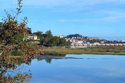
A walk along the River Nansa 7.5 kms, easy (or 15 kms out and back)
General
An interesting and varied walk along the valley of the
important Nansa River, to a small waterfall and hydro-electric station and back
along the same route. The path is marked throughout with green and white
way-markers.
How to get there and where to park
From Jct 269 of the A8/E70 (signed for the caves at Soplao and El Chufín), turn right and
then, at a roundabout, turn left towards Unquera
and Pesués, joining the N634. Soon turn left onto the CA181 following a
sign for Muňorrodero and Puentenansa. Cross a bridge and pass through the
village of Muňorrodero. As you leave the village, the route is signed on the
right. As you turn off the CA181 follow the
track to a large car park where you will also find a helpful map and
information board, picnic tables and play area.
The walk
Start by walking back along the road with the river on your right and soon arrive at two sets of wooden steps – there are a number of these as well as bridges and walkways along the route. Follow the woodland track until it splits with an option to follow the river bank or the main path. The paths re-unite after a short distance. Keep to the path as it follows the river upstream. At a little about three kilometres there are steps down to a cave which you may choose to visit and soon the path turns sharp right to again follow the river. Shortly afterwards the path splits again – both routes are signed to Camijanes - with an option to follow the main path or turn right and take the slightly shorter route, involving a rocky river crossing. The height of the river will probably determine your choice and the paths join up again after about a kilometre. Very soon afterwards there is a fork to the right taking you past a refuge and onto the only tricky section – a short, narrow stretch of path along a cliff edge, though you are supported by a hand-rail.

Eventually you will reach an open area with a view of the small waterfall and steps up to a small picnic and parking area. Depending on the height of water level in the river, for variety on the way back you may wish to follow the alternative path back to Muňorrodero.
San Sebastián de Garabandal – 4.7 km (easy)
General
A short walk taking you through the
countryside surrounding the village of San Sebastián de Garabandal, past the
religious shrine and through the village itself. Close by, you can visit the monument to La Madre del emigrante (the
mother of the emigrant).
San Sebastián de Garabandal is renowned as a shrine and place of pilgrimage following the reported appearances of the Virgin Mary and the Archangel Michael to a group of girls in the village in the 1960s. You can learn more about the apparitions and the shrine on the adjacent page, ‘Out and About in Cantabria’.
How to get there and where to park
Leave the A8 motorway at jct 269 and then follow the N634 towards Unquera. Soon, turn left onto the CA181 and stay on this road for approximately twenty km until you arrive at Puentnansa. Here, continue straight ahead – the road changes to the CA281 – towards Cosío where you turn right onto the CA860 towards San Sebastián de Garabandal. The road climbs for five kilometres brining you to the monument to La Madre del emigrante (the mother of the emigrant). On the right of the monument, you will see a large parking space. The walk starts from here.
The walk
From the parking space, head uphill
into the village, San Sebastián de Garabandal. Keep to the left of a noticeboard and
soon come to two signposts for Los Pinos. Keep straight ahead, to begin a climb
towards the shrine, passing signs for the place of the original visitations. Continue
uphill and when you reach the chapel on your right, keep right to follow a
grass path. This path soon becomes a ‘Rosary Way’ and you will pass several
illustrations of the bible story of the lives of Mary and Jesus.
The path and rosary markers wind their way up the hillside until eventually the mountains of the Peña Sagra come into view. This is a good spot for practising your photography. The track turns right and at then at a junction of paths, turn right. Soon you come to another junction. Here, keep left if you wish to follow the Rosary Way, otherwise, keep right to join the track that heads downhill. You emerge onto a gravel track where a large sign directs you right back to Garabandal. The track soon becomes a concrete road and enters the village. Keep left to pass the pilgrim’s centre and church and then leave the village to return to the start.


Pine forests and sand dunes at Liencres 4.5km Easy
General
The sand dunes at Liencres
differ in many ways from the many beaches in Cantabria: The long stretches of
beach are surrounded by sandy hills and forest land with a number of marked
trails which are linked together by this walk. This is a popular spot with
three car parks, two cafés, picnic tables and other facilities and at particular times of the year is an excellent location or spotting and identifying orchids.
How to get there and where to park
Leave the A67 at junction 195 for Bóo de Piélagos. Turn left at the T-junction and follow the CA231 through the village of Bóo and then turn left into the Parque Natural, following the sign for Playa Valdearenas. Park in the upper car park - immediately on the right as you enter. From here walk back to the forest road, walk a few yards down to the right, cross over and start your walk on a small path with a sign for Sendero de la Ría Mogro.
The walk
Follow the path marked Sendero de la Ría Mogro as it makes its way towards the sand dunes. At different points it crosses a bridle path and other tracks but the regular signs help keep you on the right path. With the wide river on your left with views of the golf course beyond you eventually, pass a large sign for Sendero de la Ría Mogro and continue to the end of the path where there is a viewing area and information panel. Re-trace steps a few yards to the large sign and take the sandy path to the left marked Sendero de las Dunas; walk down the sand bank and soon come to another information panel with a large sign for the Sendero de las Dunas. Turn right here and pass between trees and then follow the signs for about 700m, bringing you to a car park (there is a café here if you need refreshments).
Cross the road and keep to the pavement through the car park and onto the narrow road ahead. Stay on this road for about 400m; pass a sign for the Camino del Parque Natural on the right and then turn right along a narrow, sandy track towards a small stone-built pillar a little way ahead. When you reach the pillar turn right and follow the shingle path heading for a wooden viewing platform which soon comes into view. At the viewing platform, turn left to follow the Sendero del Arroyo Ganzarros through pine woods and past several information panels until you arrive back at the car park.


Riverside Walk at Bárcena Pie de Concha. 5km Easy
General
The delightful village
of Bárcena Pie de Concha is the
setting for this walk alongside the Río
Torina. The village is located in the heart of the Besaya valley between
Santander and Reinosa, adjacent to the A67 motorway and N611. At Bárcena Pie de Concha you will find the
meeting of the two rivers Besaya and Torina as well as a short section of Roman Road (see below). In addition the village is
noteworthy for being the birthplace of the twentieth century philosopher and
politician Luis Araquistain Quevedo.
How to get there and where to park
Leave the A67 at jct 157 and follow
signs for Molledo and N611. Head
south on the N611 until you turn right to enter the village Bárcena Pie de Concha. At a T-junction
turn left and then, soon, turn right following a sign to the Calzada Romana. In a small square by the
river, you will see the Tourist Information Office. There is ample parking here
as well as notice boards providing information (in Spanish) about the village
and surrounding area.
The walk
From the Tourist Information Office cross the bridge across
the river and make your way towards the church. Looking to the right you will
see a (blank) wooden signpost directing you left. Follow this road, pass under
a bridge and continue straight ahead through houses with the river to your left.
After one kilometre you arrive at an electrical power station. Stay on the road
to cross the river and very soon turn right following a sign for Variante al Río Torina, Area Recreativa.*
The road follows the river past houses and soon becomes a gravel track which
leads eventually to an open area with a picnic table, small bridge and
picturesque waterfall. Once you have enjoyed the peace and tranquillity of this
spot, retrace your steps to the road and turn right. Soon you come to a
junction, turn left and descend towards the village. Pass through a tunnel and
alongside a football stadium and then turn left. At a T-junction, turn left and
make your way through the village until you turn right, following a small sign
for the Tourist Information Office and return to the start.

Santander cliff tops 3.5km very easy
General
Our second trip around Santander starts from close to the beach area, Sardinero. A short walk around the cliffs at the western end of El Sardinero with excellent views of the beaches, town, port and landscape surrounding Santander.
How to get there and where to park
There is plentiful parking around this end of the beach but, be aware, it does get very busy at weekends and in high season. Once in the beach area head for Hotel Chiqui which is off the Calle Manuel Garcia Lago. From the hotel, make you way back on the same road until, by Bar Coronna, there are steps rising to your right. The walk starts here.
The walk
At the cafeteria, climb the steps and follow the
concrete path at the top. Soon turn right and pass along the cliff tops
underneath the golf course. When the wooden fence ends, turn right and follow a
narrow path towards rocks at the end. The rocks make an excellent viewing point
and photo location. Walking back from the rocks, follow the narrow track which
climbs to the right and follow this through rocks and along the cliff top. Soon
there is a clear view ahead of a light-house and the path leads you to a wooden
viewing point and path. The wooden path soon becomes a concrete track which you
follow around the bay and eventually arrive at a road. Turn left past the golf
club and follow the road down, keeping left. Soon, there is a gate into a park.
Enter here and follow the paths to the right. Eventually you emerge through
large double gates onto a road. At a junction by a zebra crossing, turn left
through a short alley and then right to re-trace your way back to the steps and
starting point.
 The lighthouse at Santander
At the cafeteria, climb the steps and follow the concrete path at the top. Soon turn right and pass along the cliff tops underneath the golf course. When the wooden fence ends, turn right and follow a narrow path towards rocks at the end. The rocks make an excellent viewing point and photo location. Walking back from the rocks, follow the narrow track which climbs to the right and follow this through rocks and along the cliff top. Soon there is a clear view ahead of a light-house and the path leads you to a wooden viewing point and path. The wooden path soon becomes a concrete track which you follow around the bay and eventually arrive at a road. Turn left past the golf club and follow the road down, keeping left. Soon, there is a gate into a park. Enter here and follow the paths to the right. Eventually you emerge through large double gates onto a road. At a junction by a zebra crossing, turn left through a short alley and then right to re-trace your way back to the steps and starting point.
Collada de Carmona. 9.75km Generally easy
General
You can feel really remote on this walk, although you are never far from the villages of the Cabuérniga and Nansa Valleys. You will enjoy a pleasant stroll around a natural and unspoilt area and may well come across a variety of flora and fauna as well as marvelling at stunning views of the local mountains and countryside. Starting from the Collada Carmona at 611m you climb steadily to 665m and then descend on a wide track before returning uphill to the start.
How to get there and where to parkLeave the A8/E70 at jct 249 and follow signs for Cabezón de la Sal across two roundabouts. As you approach the town take the CA180 towards Reinosa and follow the road through Cabezón. Stay on this road through the villages of Ruente and Barcenillas and then, at Valle de Cabuérniga turn right onto the CA182 towards Carmona. Follow this road uphill for a little over 4 km and then, just after a sign for a crossroads arrive at Collada de Carmona with a large parking bay on the left alongside a signpost for a walking route to Sarceda. With the signpost on your left walk to the end of the parking bay where you will find a small pillar and plaque for Collada de Carmona. The walk starts here.
The walkCross the road and go through a gate by a cattle grid to take the path that leads straight ahead. Cross another cattle grid and, very soon, keep left at a fork. Follow this path until you arrive at an intersection. Turn left here to follow the grass path – the other path is your return route. Stay on the grass track and soon enjoy views of the valley below, the Escudo Ridge in front of you and the Peňa Sagra to your left. Soon the path runs alongside a fence and you follow the fence for some 850m and then, in a hollow, instead of following the fence steeply uphill, turn right to join a grass track. This soon becomes a more distinct path and leads down to a more substantial track below where you turn right. You stay on this track for 2.75 km as it makes its way around the valley and gently descends. Ignore any minor paths to the left or right, pass a water trough on the left and a gate and holly bushes on the right and eventually, at a major intersection, turn right to start making your way quite steeply uphill. Head towards the pylons above and bear right. Continue uphill and ignore a path that descends to the left. The path follows alongside a wall for a short distance and then heads into open pasture - you might encounter horses and cattle here. Continue uphill with fine views of the surrounding villages; ignore another path to the left; keep straight ahead at the next intersection and eventually return to the path that leads back to the parking area.

Monte Corona (9 kilometres - easy)
General
An undulating nine kilometre walk visiting managed forestry,
two ermitas and the viewpoint at Monte Corona. You will enjoy some tremendous views of
the coastal towns, woodland and the Picos de Europa at different points on this walk.
How to get there and where to park
Leave the A8/E70 at jct 249 and at the roundabout take the exit for Comillas on CA135. After 3.5 Km you
reach the small village of La Hayuela.
Turn left here by a panel and entrance to the Parque Natural de Oyambre
with a sign-post for Monte Corona and
Camino Forestal. Ignore the access road to the houses on the left and then keep left to follow the rough tarmac road and after nearly
two kilometres, just before the red and white observation tower, you reach a
fork in the road. Take the right-hand
fork and then follow a sign for San
Esteban. Continue on this road downhill until you come to a parking area on
the left. The walk starts here.
The walk
From the parking bay turn left on the road past a picnic area on your left towards the ermita San Esteban. Going into the grounds of the ermita you find a helpful panoramic diagram of what lies in different directions. Returning to the track, make your way past the ermita on the tarmac road to the right and begin a lengthy steady descent on a wide path through eucalyptus trees for about two kilometres, ignoring other roads on the right.
At a T-junction at the foot of the descent, turn left and begin a steady climb of a further two kilometres which brings you to another T-junction. Here, turn right and make your way towards the ermita San Antonio where there is also a picnic area. As you approach the ermita, by a signpost for ermitas de Caviedes, turn left and immediately left again to take the track which rises steadily with the motorway on your right and then turn left at the top of the hill by a way-marker.
Descend to a crossroads and take the gravel path opposite which rises to the
left of a white panel. This road gently rises to the view-point at Monte Corona. From here you will enjoy
views of the forestry and the surrounding landscape. Continuing on the track,
you soon pass under the forestry observation tower and turn left to follow the
sign towards San Esteban. Continue downhill
to return to the starting point.


Saja-Besaya Natural Park (15km, out and back - generally easy)
General
A steep climb through forestry on a well marked track, takes you into open terrain and then onto a high ridge from where you will be be rewarded with spectacular views of the Picos de Europa and surrounding
mountains and countryside.
How to get there and where to park
Leave the A8 motorway at junction 249 and follow the N634 towards Cabezόn de la Sal. As you enter the town, turn right onto the CA180. Follow this road south until you reach Valle de Cabuérniga where the road number changes to CA280. Continue southwards and pass through the village of Saja. One and a half kilometres further on, immediately after a right turn, is the Centro de Interpretación de Saja where there is a car park. Enter the centre via a wooden gate.
The Walk
From the Centro de Interpretación de Saja, turn right and walk for about 500m passing a sign and track on the right towards La Cueva de Poyo and eventually arriving at a sign for Los Collados on the right-hand side of the From the ‘Collados’ sign, the track ascends quite steeply through woods for 5 kilometres. The woods afford opportunities to spot wildlife and identify the various trees and there are occasional glimpses of the surrounding scenery. Eventually, the trees become less dense and there is more evidence of the landscape and as you emerge into open ground, the track turns sharply to the right with a red and white way-marker to help identify the route. The track continues across open terrain for a further kilometre before turning into a grass path for the final 200 metres. Crossing a stream (in summer), the path continues to another way-marker and to meet a group of white stones which follow a ridge. At this point there is a general intersection with several major paths heading off in different directions. This is the highest point of the walk (1100m above sea level) and is a good spot to pause, enjoy the spectacular views and to ‘re-fuel’ for the descent.

Cambera de los Moros (14km moderate) - San Vicente del Monte
General
A varied and substantial walk involving a steep ascent – part of which goes over a restored Roman Road – 5 kilometres along a ridge, Sierra del Escudo de Cabuérniga - and a steady descent through woods to return to the village of San Vicente del Monte. At different points on the ascent and along the ridge you will be rewarded with magnificent views. Both the ascent and descent are steep and some parts of the ascent along the Roman Road involve an element of scrambling as do the rocky sections of the ridge. The ridge is quite exposed in parts and the walk involves over 500 metres of ascent. Please make sure you are suitably prepared and equipped!
How to get
there and where to park
Leave the A8/E70 at jct 249 and at the first roundabout
follow signs for Cabezón de la Sal.
At the next roundabout turn right onto the N634 towards Treceňo. After approximately 4 km turn left towards San Vicente del Monte (CA851). After a
further 5 km you arrive at the village (located at 320m above sea level) and
there are a number of places to park in the village. Near the Posada Bolera and opposite the bowling
alley (bolera) there is an
information panel with a map and profile describing the route. The walk starts
from here.
The Walk
Head west out of the village and very soon turn left onto a
grass track which descends to a gravel road below. Here turn left and follow
the road and at a crossroads go straight ahead, following the yellow and white waymarkers.
Pass between two cottages and then start making your way uphill. Cross a small
stream and soon turn left following a sign. Then, by a converted water tower,
turn right onto a grassy track to follow the waymarkers. Pass through two gates
and then after the third gate turn right downhill. Cross a small stream and
arrive at a group of houses where you turn left onto a tarmac road. After short
climb there is a further information panel describing the route and here you
turn left onto a forest track. Very soon – less than ten metres – turn left and
then right to climb steps. This is the beginning of the ascent towards the
section of Roman Road and there are a number of signposts indicating how far
remains to the start of the Roman Road. At first the path climbs steeply
directly up the side of the hill. You then continue uphill following a series
of turns and eventually arrive at a post marking the start of the Roman Road.
The huge stones that form the road continue uphill. At times the path reverts
to a grass track and can become indistinct though there are usually yellow and
white markers painted onto rocks to guide you.
Eventually you arrive at a large rock alongside a fence. From
here you may enjoy views of San Vicente
el Monte below, the Picos de Europa to
the west and the Cantabrian coast to the north.
From this point the path generally follows the fence uphill with
yellow and white waymarkers painted onto the rocks until you reach an
intersection with another fence and turn left. This marks the beginning of the ridge
following the Sierra del Escudo de
Cabuérniga. This section continues for approximately 5 kilometres. Keeping
the fence to your right, make your way uphill and soon come to an information
panel – a little to the left of the fence - which explains the view to the
north. Keep left to pass a large group of rocks and then return to the fence
and soon come to a point marking the Cueto
de Herranz García (860m above sea
level). Ignore a stile across
the fence and make your way towards the next set of rocks with a small
communications tower on top. Again, pass to the left of the rocks and then
follow the waymarkers to return to the fence.
Your next target is a large cross which you can see in front of you.
Pass the cross and at the next rocky outcrop keep right to follow the path
behind the rocks.
From this point onwards the path along the ridge becomes less
distinct as it heads gently downhill - although there are regular waymarkers - and
it is best to keep close to the fence wherever possible. Pass a place marked Lisoza, ignore another stile and
eventually reach a fork with a notice indicating Ruta Principal. Take the left fork to begin a steady descent
through trees. At a fork keep left to continue the descent, ignoring a large
sign for Piralba and at a junction turn left to start making your way towards San Vicente el Monte. Stay on this path
as it crosses a stream and undulates generally eastwards. Eventually pass
through a gate by a farm building and soon reach a tarmac road and turn left
uphill past houses and farms. Stay on the tarmac road and ignore a yellow and
white waymarker to the left by a forest track – this marks the end of an
alternative descent from the ridge - and then make your way back to the village
and starting point.


A short section of the Camino de Santiago (10 km easy)
Comillas to San Vicente de la Barquera
General
If you have admired the numerous pilgrims walking the Camino de Santiago and wondered what it would be like to join them, then this walk gives you the opportunity to sample a short stretch of the route and enjoy some wonderful Cantabrian scenery along the way. This one way route involves catching a local bus from San Vicente de la Barquera to Comillas and then walking back.
How to get there and where to park
San Vicente de la Barquera is signposted from junction 264 of the A8 motorway. The bus station is located close to the roundabout at the entrance to the town where you will also find a large car park. From the bus station, catch the local bus La Cantábrica to Comillas. The bus stops alongside the car park beneath the Sobrellano palace. The bus timetable can be consulted here Bus timetable
From the bus-stop, turn away from Comillas and, staying on the same side of the road, follow the footpath away from the town. The walk starts with a short section through a park in the shadow of El Palacio Sobrellano. Continue to a roundabout where you go straight on following the CA131 towards San Vicente. After nearly two kilometres, there is a shore-side bird-watching spot with a useful display of the most common birds to be seen. At this point (Ria de la Rabia), cross the road and continue along the path. At various points along this stretch the red path takes you alongside the estuary with good opportunities to spot egrets, plovers, mallards and other water birds. A further 1500m along the road, just as you cross the Ria Capitán, take the right turn (CA236) towards Oyambre, soon to arrive at Playa Oyambre where there are toilets and bars.

The green footpath continues up-hill and it is worth taking a short (or longer) break at La Gerruca where you can enjoy splendid views of both the Picos de Europa and the beach. Just beyond La Gerruca is a track that takes you down to the beach and, depending on the tide and weather, you can return to San Vicente along across the sand.
Otherwise, the path follows the coast and during the summer (April-October) there are toilets at the different points where it comes close to the beach. Eventually, as you pass a sign informing you that you are leaving La Braňa, take the steep road down to the right. This brings you to the beach at Merón and from here you can follow the road back to the bus terminal, crossing the Puente de la Maza bridge, for a total journey of 10.5 kilometres.

Mountain refuge from Collado de Carmona (10 km easy)
General
Following this ten kilometre walk to a mountain refuge – 5km each way – you will be provided with some of the most spectacular mountain scenery to be enjoyed in Cantabria. You will also be able to look down onto both the Saja and Nansa Valleys. The route is entirely on wide gravel tracks and climbs steadily from 611 metres (2,000ft) above sea level to approximately 910m (3,000ft). Some of the ascents (and subsequent descents) are quite steep in parts and when it is windy the ridge can feel quite exposed.
How to get
there and where to park
Leave the A8 motorway at junction 249 and follow the N634 towards Cabezόn de la Sal. As you enter the town, turn right onto the CA180. Follow this road south until you reach Valle de Cabuérniga where you turn right onto the CA182. The road climbs for a little over four kilometres until you reach the top. There is a wide parking bay on the left.
The walk
Cross the
cattle grid to follow a sign towards Sarceda and continue straight ahead on the
gravel track. After two and a half kilometres you arrive at a junction. Keep
straight ahead, ignoring a path on the right, and head towards the trees and,
after one further kilometre, the refuge and a mast come into view. You will
have views of the Peña Sagra to your right and high
mountains of Asόn to your left, while looking north
you will be able to pick out the coast and the mountains of Asturias.
Eventually
you arrive at a junction of paths and begin the final climb to the refuge.
Here, you can enjoy wonderful panoramic views and the steps of the refuge
provide a suitable spot for a snack or picnic before retracing your steps.
This route
is accessible all year round but in winter you may have to pick your way over
snow and ice and care should be taken on particularly windy days.
Besaya walking and cycle path at Suances (12 km easy)
General
The
dedicated pathway between Suances and Torrelavega follows the River Besaya inland. Shared by cyclists and
walkers this route provides a wealth of points of interest along the way. The first six kilometres takes you past a wide estuary; vestiges of
Suances’ industrial heritage; modern industry in the shape of a water treatment plant and a sulphur
factory; spots for fishing and rock climbing; and the confluence of the Rivers Saja and
Besaya. The route is ideal for birdwatching; there is a well maintained hide
after four kilometres with illustrations and labels (in English) of the species
that most frequently visit the area.
How to
get there and where to park
Leave the A8
motorway at jct 234 and follow signs for Santillana del Mar. Stay on the CA136
across a number of roundabouts heading for Suances. Eventually you arrive at a
roundabout and turn right onto the CA351 towards Suances. When you reach a
T-junction in the centre of the town, turn left and head downhill. As you
approach the bottom of the hill a sign directs you right towards Playa de la
Ribera. The road bends right and then you arrive by a small football stadium.
Turn left here and you will find ample parking as well as a number of
restaurants and bars.
The walk
From the car
park, walk along the road keeping the football stadium on your left. At the end
of the road, you will see an entrance onto a path which leads you through a park.
As you emerge from the park turn left – there is a beach bar (chiringuito)
opposite and from here the path is shared with cyclists. The wide estuary to
your left is home to a vast number of water birds and you may spot avocets,
curlews, kingfishers, godwits, egrets, swans, green and redshanks. In spring
and autumn, the estuary is a resting place for migratory birds.
The path
continues over pontoons and past a number of benches and picnic tables. At four
kilometres you reach a water treatment plant where, to the left you will see
the hide, ‘Tarro Blanco’ (shelduck). From here the path continues towards the
‘Barrio San Martín’, passing a sulphur works on the
right, and two kilometres beyond the hide, you reach a large recreation area
with picnic tables and barbeque points.
The total distance from the car
park in Suances to the recreation area is a little over six kilometres and you may
of course choose to cycle rather than walk.


Around Cos (10km easy)
General
The
picturesque village of Cos lies close to the River Saja and the hills that
provide a backdrop to the village make for excellent walking terrain. With this
walk, not only do you get to tread an important historical route and sections
of a modern sporting challenge, you are also presented with two options for the
return journey and can choose between two bars for refreshments at the end of
your day.
After a
fairly steep ascent, you soon enjoy great views of the Escudo ridge and the
Saja Valley before returning via a section of the 10 000 de Soplao – an annual
sporting challenge. Close by, the village of Mazcuerras is an active arts
centre in the region with regular exhibitions and outdoor installations.
This area of Cantabria forms part of the Ruta de los Foramontanos – a route connecting Cantabria to the meseta, employed in the eighth century by Christians escaping the invading Moors and subsequently in the early stages of the Reconquest. You can find out more about the Ruta de los Foramontanos on an adjacent page of this blog.
How to
get there and where to park
From junction 249 of the A8 motorway follow the signs for Cabezόn de la Sal. At the entrance to the town, take the CA180 towards Reinosa. After three kilometres at Santa Lucía, you will see a large car park and two restaurant/bars on your right as well as a small chapel (ermita Santa Lucía). The walk begins here.
The walk
From the car park, turn right along the road and soon a cross
a bridge over the River Saja. Turn left and after a short distance, cross the
road and pass to the left of a restaurant and then turn right to begin your
ascent. The concrete track winds its ways steadily uphill for about 500 metres and
from then is a mixture of concrete, dirt and gravel tracks. Soon you cross a
cattle grid and continue uphill. At different points on this section, you will
catch sight of the mountains to the south and west, the Escudo ridge, the town
of Cabezόn de la Sal
with its textile factory and the River Saja. After a further 500m, ignore a
wide path to the left and continue straight ahead, heading into more open
country.
After nearly two kilometres of climb you reach a plateau with
a red and white marker and clump of rocks on the right. From here you will see
the Picos de Europa to the west and the rolling hills of the Saja Valley in
front. The path starts a gentle descent and different points you will pick out
the villages Ruente and Ucieda below. Pass a cattle pen on your left and then,
a little further on, you will see a red and white marker on the right. Ignore
this sign and continue downhill to the other marker you can see below.
At the junction of paths, you will see a marker for Soplao
10,000 and you turn left to follow the main path northwards. This path takes
you to the right of a hill and then, as you reach the brow, you will see the
coast ahead and the town of Cabezόn de la Sal and the surrounding
villages. On a particularly clear day, the high mountains of Asόn to the east come into view. The
path now heads steadily downhill and another path joins from the left as you
keep right. Continue your descent, keeping to the main path and ignoring other
tracks to the left and right until eventually, on a corner, you arrive at a
Soplao 10,00 marker indicating right. Ignore this marker and keep left to
continue downhill. You soon arrive at the outskirts of the village of Cos,
cross a small bridge over a stream and keep right through the houses to reach
the main road. Here, you have two options;
If you turn left and follow the main road for approximately one
and a half kilometres – keeping to the marked footpath – you will eventually
return to the bridge at Santa Lucía from where you re-trace
your steps to the start for a walk of a little over nine kilometres.
Alternatively, turn left, cross the road and then turn right
by a bench and Ruta de los Foramontanos information panel. This path
leads you through farmland, past a riding stables and then you arrive at a
large bridge. Cross and turn left. This wide path will eventually lead you back
to the CA180 at Carrejo where you turn left to return to Santa Lucía. This option
involves a total distance of approximately ten kilometres.


Punta Parayas - Seve Ballesteros airport (7.5km easy)
General
So, a walk around the perimeter of an airport might seem an unlikely recommendation and it is the case that this dedicated walking and cycle path will take you alongside a couple of Santander’s industrial and commercial sites, but you will also pass by a marina and the estuary of the River Boo, enjoy wonderful opportunities for bird spotting and have great views of the Santander waterfront, the docks and huge cranes at Astillero, and the village of Pedreña. Plane spotters may enjoy the variety of traffic at the airport itself. You will also find a small cafeteria and safe swimming area at Punta Parayas. The interior of the airport complex is also a haven for birds and other wildlife – apparently airports are a relatively safe environment since predators are put off by the loud noise and extensive human activity.
As you
follow the waterfront away from Punta Parayas, you will see the village of
Pedreña across the bay. The regular boat service from Santander to
Somo stops at the dock here and the
shoreline that runs along this side of the bay includes golf courses, mud
flats, farmland and woods. A well-maintained coastal path will take you as far
as Pontejos (about eight kilometres) and the area is a fantastic spot for bird
watching and wildlife spotting and you may get to see the pair of sea eagles
that spend the summers in an adjacent bay (Ria de Cubas). There is also an
intriguing assortment of trees, shrubs and grasses to admire and identify as
you pass along the shore. The sea eagles are monitored and cared for by the
Osprey Centre, located in Rubayo. The Visitor Centre also provides bird
watching and botanical walks as well as courses and boat trips. For more birdwatching suggestions, see our adjoining page.
How to get there
and where to park
Leave the S10 at junction 3 and follow
signs for the airport. At the roundabout at the entrance to the airport, rather
than enter the complex, take the first exit towards Maliaño. Keep left and
uphill, past a church, until at a T-junction you turn left onto Avenida
Parayas. This road will lead you to the car park and recreation area at Punta
Parayas.
The walk
This is essentially a 7.5km (four and
a half miles) circular walk around the airport and you should be aware that the
path is shared with cyclists and, on the waterfront, there are spots for
anglers, so a degree of care needs to be taken.
From the recreation area follow the
path to the waterfront and turn left. Here you may see waterbirds such as
egrets or grebes and you will enjoy views of Santander and Pedreña. You pass through a tunnel and soon
turn left with the airport on your left and the marina on your right. As you
continue along this long road, with commercial properties and warehouses to
your right, it is worth keeping an eye on the interior of the airport where you
may see ducks, gulls and other wildlife such as rabbits and small rodents.
Eventually
you arrive at the motorway and keep left and then left again to approach the
airport. You then need to cross the road and follow the path as it runs
parallel to the airport road and heads into a short, wooded section before
emerging back at Punta Parayas.

View across the bay from Punta Parayas
Cascadas El Bolao, Cóbreces (7.5 km easy)
General
A short walk
(7.5 km) taking you from the Cistercian monastery of Santa María Viaceli across open farmland to the waterfalls at El Bolao
and then returning along the cliffs. Great views of the coast and crops with
occasional sightings of various gulls, cattle egrets and different birds of
prey. The waterfalls are probably at their most dramatic in late winter or
early spring or following particularly heavy rainfall.
How to get there and where to park
From Comillas follow the CA131 for about eight kilometres. Soon after you enter Cóbreces, turn right on the CA353 towards Novales. Go past the monastery and the adjacent church of San Pedro and soon there is a car park on the left. The walk starts from here. If you are travelling from Santillana del Mar, the turning to Novales will be on the left.
The walk
Start
downhill, going back past the church and monastery and when you get to the main
road turn left and cross to visit the Ermita San Roque, dating from the
seventeenth century. From here continue towards the next church that you can see,
The Church of San Felices, with its original Gothic arch and adjacent cemetery.
Inside the cemetery, you will find a Cristo, designed by the renowned local sculptor,
Jesús Otero (Santillana del Mar 1908-94).
Continue on the tarmac road towards the coast and head for a mast that you can see ahead. Then, take the second turning on the right and aim for a small hut. Here. you turn left to Bolao. Soon you arrive at a small car park and from here you can descend to the waterfalls.
As you return from the waterfalls you will see a narrow track heading right towards the cliffs. Follow this track alongside fields and with the sea to your right. At times the path is very close to the cliff edge but you will enjoy good views of the Picos de Europa, Peña Sagra and the beach at Luaña. After about 1200m you come to a narrow path that heads inland alongside a fence. Make your way uphill towards the communications tower and soon come to a substantial track. Turn right and then keep left to head downhill and retrace your steps to the cemetery and from there back to the start.

Caves and mythological creatures at Monte Tejas. 10 km easy.
General
This very easy route of about nine kilometres, takes you past the caves at Hornos de la Peña and from there to the refuge at Monte Tejas. Along the way you will encounter some fabulous creatures from Cantabria's mythology. The tarmac and gravel tracks make it ideal for winter and you will enjoy the shelter of oak, beech, holly and yew trees.
How to get
there and where to park
The starting
point, Tarriba, is close to San Felices de Buelna and is accessed from jct 172
of the A67 motorway and then following the CA170. In the centre of the village
is a large recreation area where you will find a car park.

Hornos de la Peña
The walk
Once you have passed the caves, the route continues via a number of crossings over the River Tejas towards the refuge of the same name. Shortly after you pass a recreation area on your left, the track climbs and then a wide path leads you down towards the river where you will see a carved creature in the woods. Make your way down and you will find more creatures and carvings. Cross the river by the stones and then follow the path uphill, spotting more fantastic figures and then at a junction of paths, take the narrower option to the right. Eventually you arrive at the gravel track and looking down to your left you will next figure. Across the track there is another path leading into the woods. Follow this path and you will encounter yet more creatures.


Return to the main path and turn right. The track climbs gently and you may enjoy good views of the peaks at Dobra and Ibio as well as the Peña Sagra in the distance. There are a couple more figures on this section and then you ignore a grass track to the left and eventually, you pass two stone pillars and turn left to begin a steady descent towards the village at Tarriba. Keep left at the next two junctions and when you reach the outskirts of the village, turn right and make your back to the start.
General
This popular
route allows you the opportunity to tread along a Roman Way, thought to date
from the first century BC, and then return via a spectacular, winding train
journey. You park in Bárcena de Pie de Concha and walk
approximately 7.5 kilometres to Pesquera from where you catch a local train
back to the starting point. The walk entails some 400m of ascent and in order to
allow time for stops, photos and picnic you probably need to allocate three
hours for the walk - you can consult the train timetable here Train timetable.
How to get there and where to park
Leave the
A67 motorway at jct 157 and follow signs for Molledo. Take the N611
south for just over five kilometres and then turn right into Bárcena de Pie de Concha. Stay on the road into the village and at a T junction turn
right to the railway station where you can buy your ticket (there is no ticket
office or machine at Pesquera). Then follow the main road back through Bárcena until you are directed right to the Tourist Office.
Here you will find ample parking as well as a number of information panels.
The walk
From the
Tourist Office cross the bridge and follow the sign towards Pie de Concha. Follow
the road for a little over one kilometre, admiring the floral decorations of
the houses along the way. Eventually you arrive at an information panel and
turn sharp left to begin your ascent. Continue climbing for about 500 metres
and then, at a junction, turn right.
Follow this
track as it makes its way through the woods and when you reach a fork, keep
right and soon pass a well maintained building, La Retuerta. When you reach
a major fork, keep left and then, after about 100 metres, the track swings left
to cross the railway track and at the next junction, keep right and soon arrive
at the small village, Media Concha. Here, keep left to make your way
through the houses and soon resume the forest track. After about one more
kilometre, a sign directs you left and uphill and when you arrive at another
sign for El Bosquesuco, keep right to arrive at Somaconcha. This
small cluster of buildings is also home to the Ermita de Nuestra Señora de Somaconcha.
From here you
continue straight ahead on a tarmac path and soon arrive at a major crossroads.
Go straight ahead and downhill, cross the motorway and eventually arrive at the
village of Pesquera. At the T-junction, turn left and soon arrive at a park
with picnic tables and information panels describing the Calzada romana. From
here, pass through the railway arches and soon turn left to climb up to the railway
station.


Pesquera
A longer,
circular walk from Bárcena de Pie de Concha which takes in the local peak, Pico
Jano, can be found in our collection Circular Walks in Cantabria.
Around San Vicente de la Barquera (8 km easy)
General
Having enjoyed the walk from Comillas to San Vicente, earlier on this page, you may like to try this rural tour through countryside and villages close to the town.
How to get there and where to park
Leave the
A8/E70 at jct 258 and follow signs for San Vicente de la Barquera. At the
roundabout at the entrance to the town go straight ahead (Centro Ciudad/Oviedo) and park in the large car park by the bus
terminal.
The walk
Start from
the roundabout at the entrance to the town and take the road towards the
motorway signposted Acebosa (CA843),
walking on the pavement on the right. Cross the Ría San Vicente on two bridges and then, after nearly a kilometre,
turn left on a road indicated Abaňo. This
road skirts the marshes and there are usually good opportunities to spot
water-birds and birds of prey, including marsh harriers. Follow the road past
farmland and between eucalyptus trees to reach the village of Abaňo. Shortly after entering the village,
turn right opposite a white and red garage; go past a small recreation area on
your left and a church on your right and continue on this road towards the
motorway and Acebosa, passing the
ruins of a medieval abbey on the left. At the junction by the motorway
interchange, go straight ahead and after about 150 metres turn left to cross
the railway tracks at the level crossing to enter Acebosa. Continue through the village, passing a bus-shelter to the
left and two boleras on the right before
turning right opposite another bus-shelter. You are now on a section of the Camino Norte de Santiago. Keep to the
left to pass between houses and then gently climb to cross bridges over the
railway and the motorway. Shortly after crossing the motorway, look back and
left for brilliant views of the Picos de Europa. Stay on this road past farms
and the Posada Las Calzadas, enjoying
the excellent views of the town, bay and surrounding area. Bear right past two
hotels before descending to a T-junction. Turn right and continue the short
descent back to the starting point.

A short walk in a little visited area of Cantabria with the
opportunity to climb to a brilliant vantage point from where you will enjoy
wonderful panoramic views. The village is located about 7 kilometres from Solares and the walk takes you through one of Cantabria's former mining areas. The route is just under three kilomtres, although if you choose to make the short ascent to Pico Elechino, you add a further 500 metres.
How to get there and where to park
From junction 197 of the A8 motorway follow the signs to Hoznayo and Entrambasaguas to join the N634 heading east. Soon, turn right to
take the CA652 towards Entrambasaguas. Follow
this road for about one and a half kilometres and then, as you enter Entrambasaguas a sign directs you right
towards Santa Marina. Stay on this
road uphill for about another kilometre and then, at a fork, keep right.
As you enter the village of Santa Marina you will see the church to your left. There is ample parking here, alongside the play area. Adjacent to the church you will find picnic tables, a water fountain and a large map detailing walks in the area.
The walk
From the church, return to the tarmac road where you will see
a large signpost and map. The directions start here. The route follows PR-S 138
although there is only limited signage along the way.
From the signpost follow the sign towards Sendas al barrio El Convento and Hoznayo to head back down the road.
Ignore the sign you see on your right and stay on the road, passing a fountain
on your left. At the junction keep left and soon, alongside a yellow and white
marker, turn off the road onto a dirt track on the left and enter the woods.
After about 150 metres turn right onto a narrow track. The path narrows and
heads quite steeply uphill. Follow the path as it passes beneath rocks to your
right and with views of the limestone formations below. Eventually you emerge
into a more open area with views of Santander and the coast to the north and
you soon arrive at a junction of paths.
Here you have the option of turning right to make the short
but quite steep ascent to Pico Elechino (also
known as Pico Vizmaya) which is at
248m (815ft) above sea level. The
distance to the summit is 200m and the ascent is approximately 75m and you do
have to pick your way through rocks for a short section. It is well worth the
effort since the views from the trig point on the summit are truly amazing: you
will see Santander and the coast to the north and Peña Cabarga to the east with the impressive Peña Sagra and the Picos de Europa
further east and to the south. Looking south west you will be able to pick
out the high mountains of the Asón area.
You need to take particular care on the descent and when you
return to the junction of paths take the second track on your right to
start heading downhill (if you decide not to climb Pico Elechino, turn left and then immediately right when you arrive
at the junction). The path heads steadily downhill for a little more than 200m
and then, when you reach a junction with a path on your left, turn left to
enter an area of eucalyptus trees and at the next junction keep straight ahead,
ignoring paths to the left and right.
As you make your through the woods you will see the colourful beehives on your right – you may well hear the bees here as well. At a shelter, keep left and soon you will return to the crossroads and signpost in Santa Marina.


No comments:
Post a Comment